I get asked a lot as to why GIS. Why study it when I already hold a Master’s in Cybersecurity and more IT degrees and certs than anyone cares to count. By now I could have stopped. I could have sat back, waved the certificates, and called myself an expert. But here is the truth. I do not consider myself
I’m excited to share that I’m currently working through the Cartographic Creations in ArcGIS Pro learning path on Learn ArcGIS.This series focuses on making maps that not only work, but also communicate by combining data, layout, symbology, charts, and narrative into a cohesive visual story. (learn.arcgis.com) So far, I have tackled: A few reflections: Next steps include finalizing the layout,
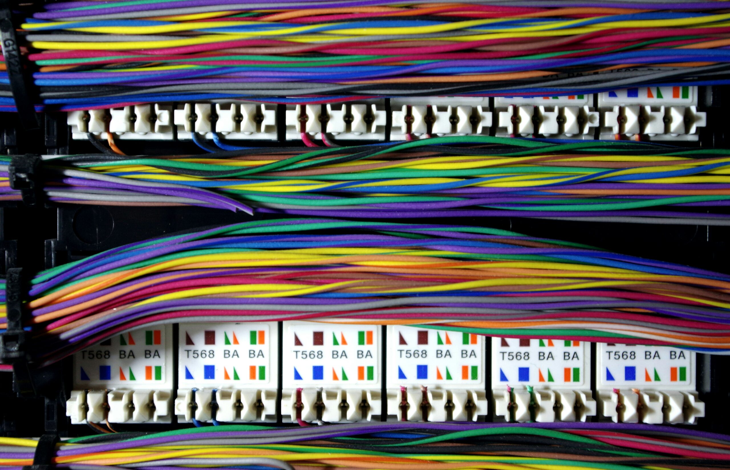
Want to know how a business actually works? Follow the money. Want to know how an IT system works? Follow the diagram. If there is no diagram, good luck. You are stumbling blindfolded into a minefield with a cigarette in your mouth, hoping the gods of uptime take pity on you. Most people treat network diagrams like a chore. A
Maps have always been sneaky. They are supposed to tell us where things are, but the truth is every map lies. Not because cartographers are villains twirling mustaches in dark basements, but because lying is baked into the very act of mapping. A map is, at best, a polite cheat. You cannot cram the real world, messy and infinite, onto
Every nation has flaws, but not every nation repeats them with the stubbornness of a drunk who swears he’s sober. We Filipinos have perfected the art of messing things up, proudly, consistently, and sometimes cheerfully. From politics to culture to economics, we manage to sabotage ourselves with a creativity that could have made us great if only it were directed
Drive across the Philippines and you will find them. Bridges that end in rice paddies. Roads that fade into gravel before reaching a barangay. School buildings locked, without teachers or students, but with the politician’s name engraved on a plaque. Health centers with no doctors, no medicine, no electricity. Ghost projects. These are not accidents. They are not freak interruptions
Most people think geospatial technology begins and ends with the apps on their phones. A blue dot on a map, a voice telling you to turn left, satellites hovering quietly above. It feels simple, frictionless, even automatic. But nothing about it is automatic. Every map is a product of politics. Every dataset is contested. Every decision about who gets access,
Mention the years 1905, 1939, and 1959 in the opening lines of a geography paper and most readers will roll their eyes, expecting some crusty old theory from the 1960s gathering dust in the archives. But Pattison’s Four Traditions of Geography refuses to be a relic. It is the skeleton that still props up the flesh of the discipline. And
Fall semester 2025. The leaves are turning brown, the air is crisp, and so is your bank account balance—crisp because it’s been burned down to ash. Somewhere between the optimism of registration day and the first midterm panic attack, you’re locked in the most brutal contest in academia: waiting for financial aid. It’s the same ritual every term. You wake
I haven’t taken the CCNA yet — but I’ve already laced up my running shoes. The track is clear in front of me, painted with subnet masks, routing protocols, and the occasional cryptic Cisco exam question that looks like it was written during a power outage. This is the race I’m signing up for — the one where the finish